• Hello, please take a minute to check out our awesome content, contributed by the wonderful members of our community. We hope you'll add your own thoughts and opinions by making a free account!

Wintry Winter 2017-18 discussion

^I've found a good number of major NC snowstorms actually occurred during a +NAO. So, imo, how much a -NAO helps in the SE US is way overrated based on what has actually occurred.
At best, I think there is a weak correlation.
 
^I've found a good number of major NC snowstorms actually occurred during a +NAO. So, imo, how much a -NAO helps in the SE US is way overrated based on what has actually occurred.

Yes it definitely is... What I've found in a general sense is while it may not have a very profound effect on total snow in some cases, the sign of the NAO and/or EPO has a huge impact on the type of winter storm that can occur in the respective regime. When we have a very substantial -EPO/WPO (as we've seen the past several years), Miller B/overrunning events are favored and should be anticipated, whereas w/ a -NAO, very strong coastal lows (Miller As) are relatively more prominent especially from the Carolinas and points north.
 
Yeah, after 2014-2015 winter was such a bust, I don't think the indicies are reliable as they used to be for what actually happens here with regards to winter storms.
 
Last edited by a moderator:
Again, (& as I mentioned last winter) while the indices in general aren't reliable for wintry weather here in NC, they're actually very reliable for predicting the kind of winter storm we can expect here (if the pattern supports one). The most profound Miller A and B events of the 21st century only highlight this relationship between teleconnections and storm type in NC further...

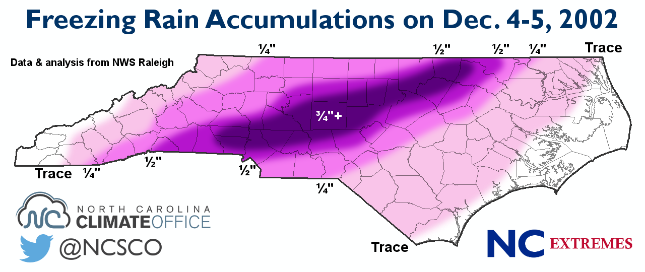
As mentioned earlier, Miller B/overrunning events are most often observed to occur in conjunction w/ North Pacific blocking (-EPO/-WPO) and what a surprise, look at the overall 500mb pattern during the devastating Dec 2002 ice storm...
Yes, while the NAO was positive, note how prominent the -EPO was during this event...
compday.PzydeqWoax.gif
infographic-2002_ice_storm.png


On the other hand, check out the 500mb pattern during the January 2000 snowstorm, one of the most classic Miller A events in the historical record for the Carolinas... There's a substantial -NAO but the North Pacific blocking that was prominent in the Dec 2002 ice storm is practically nonexistent.
compday.BiFzqbH76h.gif
accum.20000125.gif


In essence, yes we certainly can't completely rely on the sign one teleconnection or the other to have a strong, linear relationship to wintry weather here in the Carolinas, but there's an unmistakable relationship on where the high latitude blocking is located and whether or not we end up with an ice storm, or large coastal low w/ a sharp rain/snow line...

Generally speaking, -EPO/-WPO favors Ice storms while -NAOs are more conducive to coastal lows
 
Further to the above about how much a -NAO is overrated for major SE snow chances. I just compiled for the first time ever the NAO for all 21 Raleigh 6"+ SN/IP storms since 1950. (I'm calling neutral NAO to be from +0.25 to -0.25):

-1/19/1955: -NAO
- 12/11/1958: neutral NAO
- 3/2-3/1960: neutral NAO
- 3/9/1960: neutral NAO
- 2/26/1963: neutral NAO
- 1/25-7/1966: -NAO
- 2/9/1967: +NAO
- 3/1/1969: -NAO
- 1/7-8/1973: -NAO
- 2/18-9/1979: neutral NAO
- 3/1-2/1980: +NAO
- 1/13-14/1982: neutral NAO
- 3/24/1983: neutral NAO
- 2/6/1984: +NAO
- 1/7-8/1988: +NAO
- 2/17-8/1989: +NAO
- 1/24-5/2000: -NAO
- 1/2-3/2002: -NAO
- 2/26-7/2004: -NAO
- 12/25-6/2010: -NAO
- 2/24-6/2015: +NAO

Tally:
-NAO: 8 (38%)
Neutral NAO: 7 (33%)
+NAO: 6 (29%)


Not included in the above tally but an honorable mention since Raleigh didn't get heavy snow from it but many others did: 3/12-3/1993 Storm of the Century: +NAO

Conclusion: With results like this and a pretty nice sized sample, I feel one has to conclude that any correlation of -NAO with heavy SE US SN/IP is negligible at best.
 
Last edited:
Further to the above about how much a -NAO is overrated for major SE snow chances. I just compiled for the first time ever the NAO for all 21 Raleigh 6"+ S/IP storms since 1950. (I'm calling neutral NAO to be from +0.25 to -0.25):

-1/19/1955: -NAO
- 12/11/1958: neutral NAO
- 3/2-3/1960: neutral NAO
- 3/9/1960: neutral NAO
- 2/26/1963: neutral NAO
- 1/25-7/1966: -NAO
- 2/9/1967: +NAO
- 3/1/1969: -NAO
- 1/7-8/1973: -NAO
- 2/18-9/1979: neutral NAO
- 3/1-2/1980: +NAO
- 1/13-14/1982: neutral NAO
- 3/24/1983: neutral NAO
- 2/6/1984: +NAO
- 1/7-8/1988: +NAO
- 2/17-8/1989: +NAO
- 1/24-5/2000: -NAO
- 1/2-3/2002: -NAO
- 2/26-7/2004: -NAO
- 12/25-6/2010: -NAO
- 2/24-6/2015: +NAO

Tally:
-NAO: 8 (38%)
Neutral NAO: 7 (33%)
+NAO: 6 (29%)


Not included in the above tally but an honorable mention since Raleigh didn't get heavy snow from it but many others did: 3/12-3/1993 Storm of the Century: +NAO

Conclusion: With results like this and a pretty nice sized sample, I feel one has to conclude that any correlation of -NAO with heavy SE US SN/IP is negligible at best.
Larry,
Sitting down here on SW 13th Street, on the lake, and should not be looking, but am ... :eek:
Any idea on the PNA set-ups on any of those?
Best!
Phil
 
Larry,
Sitting down here on SW 13th Street, on the lake, and should not be looking, but am ... :eek:
Any idea on the PNA set-ups on any of those?
Best!
Phil

I just did a similar tally for PNA for the 21 individual 6"+ SN/IP storms at Raleigh since 1950 (I'm calling +0.25 to -0.25 neutral PNA):

+PNA: 10 (48%)
Neutral PNA: 8 (38%)
-PNA: 3 (14%)

Not included in the above tally but an honorable mention since Raleigh didn't get heavy snow from it but many others did: 3/12-3/1993 Storm of the Century: neutral PNA

Conclusion: I think one has to conclude that there's a good chance that there is a stronger correlation between a +PNA and a heavy SE snowstorm than a -NAO and the same. At the minimum, I'd much rather have either a +PNA or neutral PNA than a -PNA for heavy SE snow chances since 18 of the 21 (19 of 22 if include 3/1993) had either of those.

Edit: Addendum: the only 3 -PNA big RAH SN/IP were the two in March of 1960 and 2/24-26/2015, and the 2/24-6/2015 storm was only borderline -PNA. So, RAH went nearly 55 years between getting -PNA big snowstorms!
 
Last edited:
I just did a similar tally for PNA for the 21 individual 6"+ SN/IP storms at Raleigh since 1950 (I'm calling +0.25 to -0.25 neutral PNA):

+PNA: 10 (48%)
Neutral PNA: 8 (38%)
-PNA: 3 (14%)

Not included in the above tally but an honorable mention since Raleigh didn't get heavy snow from it but many others did: 3/12-3/1993 Storm of the Century: neutral PNA

Conclusion: I think one has to conclude that there's a good chance that there is a stronger correlation between a +PNA and a heavy SE snowstorm than a -NAO and the same. At the minimum, I'd much rather have either a +PNA or neutral PNA than a -PNA for heavy SE snow chances since 18 of the 21 (19 of 22 if include 3/1993) had either of those.

Edit: Addendum: the only 3 -PNA big RAH SN/IP were the two in March of 1960 and 2/24-26/2015, and the 2/24-6/2015 storm was only borderline -PNA. So, RAH went nearly 55 years between getting -PNA big snowstorms!

Very interesting (says me, Sgt. Schultz, here) ... and that does make me feel good, since even though it only snows in Gainesville when God is napping and therefore doesn't know, I've often and for a long time felt that the PNA is our local bus driver ... this gives me more confidence in my " 'sposin' " ...
Thanks, Larry!
Phil

YW. When I get more time, I plan to do AO and EPO. Now I'm really curious!
 
YW. When I get more time, I plan to do AO and EPO. Now I'm really curious!

For Raleigh 6"+ SN/IP since 1950:

AO: assuming neutral AO to be +0.5 to -0.5
6 -AO; 8 neutral AO, 7 +AO

3/1993 Storm of Century had +AO

So, little signal from AO, not too dissimilar to NAO's weak signal.

NAO/AO combo: Out of 21, 4 were -NAO/-AO and 4 were +NAO/+AO...so, little signal from the NAO/AO combo

EPO: (assuming neutral EPO +50 to -50)
Out of 21, 7 -EPO, 8 neutral, 6 +EPO
3/1993 Storm of Century had -EPO

So, little signal from EPO.

My conclusion: PNA is the #1 best indicator of PNA, NAO, AO, and EPO for major SE US snowstorms

Addendum: Storm of the Century 3/1993: neutral PNA, +NAO, +AO, -EPO
 
For Raleigh 6"+ SN/IP since 1950:

AO: assuming neutral AO to be +0.5 to -0.5
6 -AO; 8 neutral AO, 7 +AO

3/1993 Storm of Century had +AO

So, little signal from AO, not too dissimilar to NAO's weak signal.

NAO/AO combo: Out of 21, 4 were -NAO/-AO and 4 were +NAO/+AO...so, little signal from the NAO/AO combo

EPO: (assuming neutral EPO +50 to -50
Out of 21, 7 -EPO, 8 neutral, 6 +EPO
3/1993 Storm of Century had -EPO

So, little signal from EPO.

My conclusion: PNA is the #1 best indicator of PNA, NAO, AO, and EPO for major SE US snowstorms

Addendum: Storm of the Century 3./1993: neutral PNA, +NAO, +AO, -EPO
Every train has an engineer, a fireman, a brakeman and ... and a bus has a driver!
 
Every train has an engineer, a fireman, a brakeman and ... and a bus has a driver!

So, if I had to only pick one driver of the SE heavy snow bus, I'd easily pick the PNA to drive knowing that there's the small chance the PNA might be drunk and have a bad accident!

There's no telling whether or not any of the EPO, AO, and NAO bus drivers would get us there safely. Much more random!

My research for today is completed.

Edit: When i say PNA, I mean as long as it isn't the -PNA.
 
Last edited:
So, if I had to only pick one driver of the SE heavy snow bus, I'd easily pick the PNA to drive knowing that there's the small chance the PNA might be drunk and have a bad accident!

There's no telling whether or not any of the EPO, AO, and NAO bus drivers would get us there safely. Much more random!

My research for today is completed.
With you 1000% - no index drives the weather bus (hence the train analogy) - too many variables line up differently every year - but it's nice to see a personal and considered subjective observation get some numerical credence ... ;)
Thanks for the research and time, Larry!
Best!
Phil

PS - and looking down the track and around the bend, the fireman screams and the engine just gleams ...

pna.mrf.gif


4indices.png
 
Last edited:
PS - and looking down the track and around the bend, the fireman screams and the engine just gleams ...

pna.mrf.gif


4indices.png
[/QUOTE]

SMH! Where’s my suntan lotion.


Sent from my iPhone using Tapatalk
 
Greg Fishel is revealing his winter outlook tonight on the WRAL 6:00 newscast.
 
Back
Top