• Hello, please take a minute to check out our awesome content, contributed by the wonderful members of our community. We hope you'll add your own thoughts and opinions by making a free account!

Wintry Call Maps for 1/16-1/18

Parker

Member
Joined
Jan 5, 2017
Messages
1,702
Reaction score
4,657
Location
Bluff Park, Alabama
I’m sure Chris will do a call map, but if anyone else has call maps for portions of the SE then please post them here. I enjoy seeing them and sure many others do!
 
Brad P's latest map for west-central NC. Nice to see he's at least not pedaling/regurgitating the models and/or EPS as usual at this range. He's definitely conservative to say the least.
Screen Shot 2018-01-15 at 7.41.06 PM.png
 
As stated in the graphic, my confidence is low, partly because of the NAM/GFS/EURO. I tried to be more middle of the road on this map, but I'm not sure if I really achieved that. I may have been a little too bullish in some areas. Although it's on the legend, I didn't make a prediction for 2-4 inches anywhere for this map. Depending on 00z model suite tonight that could be subject to change on a final map in the morning.
 

Attachments

  • GA Snowfall map.png
    GA Snowfall map.png
    157.1 KB · Views: 64
Huffman's latest
e337b535c05229f701cdbbe9db8107c3.jpg


Sent from my SM-G920V using Tapatalk
 
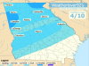
Don't like updating my map but the evidence strongly supports 3 to 5" in the zone of best upper divergence. Also adjusted colors so it isn't quite so horrible to the eye ;)

View attachment 3129

Yeah I don't like updating either but given the potential involved here and how much more aggressive NWP has become in the last several suites, etc. I might have to change mine just ever so slightly by 0z tonight, plenty of evidence emerging to support a 4-8"+ event along US-1. I obviously hate doing this but at least what I put out hasn't changed much in general and I stayed on the higher end of most forecasts, anticipating changes like these to be forthcoming
 
Back
Top