Models hinting at wintry around 1st week, then possible torch, who knows how it ends..... let'er rip tater chip.
-
Hello, please take a minute to check out our awesome content, contributed by the wonderful members of our community. We hope you'll add your own thoughts and opinions by making a free account!
You are using an out of date browser. It may not display this or other websites correctly.
You should upgrade or use an alternative browser.
You should upgrade or use an alternative browser.
Pattern Fail or Fab February 2023 Pattern Thread
- Thread starter Metwannabe
- Start date


packfan98
Moderator
Not much noise on the 6z GEFS.
Not bad ?

Yeah 6z gefs was pretty ugly but we still have arctic air not too far north, active southern stream and there will be a battle zone in there between these 2 airmasses. Where that sets up and if we can get a slp to develop and pull in some of that cold air, yet tbd obviously. I still like our chances around that timeframe and at least we still have the euro and the cmc to a degree on our side.Not much noise on the 6z GEFS.
Hug the ICON lovingly.
Should it have found the elusive SE unicorn, Iconic February should be named in its honor.
Should it have found the elusive SE unicorn, Iconic February should be named in its honor.
Snownut
Member
We just need to get to early next week and see where we are. But I think the CAD areas are going to setup right up into and ice storm.
Sent from my SM-A526U using Tapatalk
Sent from my SM-A526U using Tapatalk
The GEFS is trying to slow the trip to phase 4. It'd be nice to avoid it. Heard the Euro does avoid it but haven't seen it. I do like having cold air nearby. Likely favors climo areas of nw NC. Us along and especially south of 85 need a lot of help imo.gif")
I don't get how that thing haulz through the cold zones and comes to a screeching halt in the worst half of the circle.The GEFS is trying to slow the trip to phase 4. It'd be nice to avoid it. Heard the Euro does avoid it but haven't seen it. I do like having cold air nearby. Likely favors climo areas of nw NC. Us along and especially south of 85 need a lot of help imoView attachment 131366
iGRXY
Member
We are setup fine if the threat develops as is being depicted today. There's really an all in approach with this. The same thing has to go right for any of the CAD areas to get wintery weather in North or South Carolina and really southern VA too. Even with that much cold air to our north, if you don't get a nice HP and I mean at least close to 1040+ HP, then everybody's goose is cooked in this situation because it really will be a perfect timing type of thing. Right now traditional CAD areas like NC/SC/GA should probably have their 1-10 scale around a 3 right now which is honestly great at this lead time. But I still don't like the setup for much snow outside of some onset stuff like last year. This has ICE storm written all over it tbh.The GEFS is trying to slow the trip to phase 4. It'd be nice to avoid it. Heard the Euro does avoid it but haven't seen it. I do like having cold air nearby. Likely favors climo areas of nw NC. Us along and especially south of 85 need a lot of help imoView attachment 131366
LukeBarrette
im north of 90% of people on here so yeah
Meteorology Student
Member
2024 Supporter
2017-2023 Supporter
 Let’s move this thing south for the board. I know it bullseyes me but thats not as fun for everyone. We are getting closer now
Man, upon further inspection that Euro OP run was a dadgum beast. 925MB temps were at -9 at the peak of the storm IMBY. I think the ptypes were off due to that look so that was probably 3-4" of sleet here. Probably some really, really bad ZR for S&E wake and the sandhills.
Yeah, I still get the feeling this is a major ice storm in the making for someone.. has that classic arctic air undercutting look to it.Man, upon further inspection that Euro OP run was a dadgum beast. 925MB temps were at -9 at the peak of the storm IMBY. I think the ptypes were off due to that look so that was probably 3-4" of sleet here. Probably some really, really bad ZR for S&E wake and the sandhills.
*IF* this happensYeah, I still get the feeling this is a major ice storm in the making for someone.. has that classic arctic air undercutting look to it.
Moisture aint gonna be an issue, we know that from the last month. Wherever that gradient sets up, you better hope you're north of that ZR line.
W
WSW
Guest
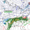
Virginia/ Mid-Atlantic special right thereView attachment 131367Let’s move this thing south for the board. I know it bullseyes me but thats not as fun for everyone. We are getting closer now
I think as usual it's going to be BOTH. LOL easy question, messin' around, but some will fail and some will win. Overall, I think if you are in the North of I-20 to I-40 with 85 corridor areas, you have time for sure. South of 20....not your year again, IMO.
Also, I think what really spooked me with that euro setup is in ice storms, we always seem to be left with a decaying airmass. That doesnt seem to be the case here.
Before anyone swoops in and tells me, YES I KNOW THIS IS DAY 8+
Before anyone swoops in and tells me, YES I KNOW THIS IS DAY 8+
actually, for the bulk of the precip, it's more like day 9Also, I think what really spooked me with that euro setup is in ice storms, we always seem to be left with a decaying airmass. That doesnt seem to be the case here.
Before anyone swoops in and tells me, YES I KNOW THIS IS DAY 8+
")
SnowNiner
Member
I don't get how that thing haulz through the cold zones and comes to a screeching halt in the worst half of the circle.
Pacific convection always seems to fight against us every winter. That to me seems to be the reason we struggle each year.
LukeBarrette
im north of 90% of people on here so yeah
Meteorology Student
Member
2024 Supporter
2017-2023 Supporter

FWIW