Lets use this thread to discuss overall patterns, whether or not we can trust the weeklies, old patterns that worked/ didn't work.
-
Hello, please take a minute to check out our awesome content, contributed by the wonderful members of our community. We hope you'll add your own thoughts and opinions by making a free account!
You are using an out of date browser. It may not display this or other websites correctly.
You should upgrade or use an alternative browser.
You should upgrade or use an alternative browser.
Pattern General Wx/Pattern Disco
- Thread starter SD
- Start date
Winter forecast until further notice.png")
BHS1975
Member
Where's Web? I need a postmortem.
Sent from my iPhone using Tapatalk
Sent from my iPhone using Tapatalk
I think he may need that as well.Where's Web? I need a postmortem.
Sent from my iPhone using Tapatalk


No real context here I just wanted to see them all together
I've seen some similar analyses done already, but figured I'd throw mine out here so we can all share in the depressing reality that is NC snowfall trends.
First, I present to you annual snowfall from 1944-1984:
.png")
'44-'84 mean: 7.44"
'44-'84 median: 5.4"
Next, 1984-2024 annual snowfall:
.png")
'84-2024 mean: 4.96"
'84-2024 median: 1.7"
Now the whole picture:
.png")
To me the thing that probably sticks out the most is the '84-2024 median of only 1.7". Once you remove the outlier years of 2000 and a couple of others, it becomes readily apparent that our winters have been really paltry for a long time now. We certainly used to get a lot more sleet/freezing rain events that don't even happen now either, but the end result of no snow has been there for a lot longer than I fully realized.
I've actually reached out to my pals at the NC Climate Office to see if they would consider pulling all hourly data where RDU measured precipitation with the temperature at or below freezing. I believe you would see a dramatic decrease in that as we roll forward in time as well. It's not just snow that has dried up - where are all the sleet and freezing rain / glaze events at? All those nuisance winter weather advisories for a glaze of ice in the morning? It's all gone.
I'm honestly starting to wonder if my kids or at least their kids will be telling stories of how it used to snow at all in Raleigh if we continue down this road. I still don't buy that this is all solely the result of climate change, because it's not like we are suddenly getting a lot of sleet events with a narrow 1-2 C warm layer or partial thicknesses are 1310 m and we are just a degree or two away from frozen precipitation. We aren't even in the ball game anymore. Who knows what the next 40 years of this graph will look like - will we snap back upwards or continue to trend to almost nothing? The 1930s and 40s probably were pretty similar in regards to snowfall to what we're experiencing now over the past 20 years, so who knows.
First, I present to you annual snowfall from 1944-1984:
'44-'84 mean: 7.44"
'44-'84 median: 5.4"
Next, 1984-2024 annual snowfall:
'84-2024 mean: 4.96"
'84-2024 median: 1.7"
Now the whole picture:
To me the thing that probably sticks out the most is the '84-2024 median of only 1.7". Once you remove the outlier years of 2000 and a couple of others, it becomes readily apparent that our winters have been really paltry for a long time now. We certainly used to get a lot more sleet/freezing rain events that don't even happen now either, but the end result of no snow has been there for a lot longer than I fully realized.
I've actually reached out to my pals at the NC Climate Office to see if they would consider pulling all hourly data where RDU measured precipitation with the temperature at or below freezing. I believe you would see a dramatic decrease in that as we roll forward in time as well. It's not just snow that has dried up - where are all the sleet and freezing rain / glaze events at? All those nuisance winter weather advisories for a glaze of ice in the morning? It's all gone.
I'm honestly starting to wonder if my kids or at least their kids will be telling stories of how it used to snow at all in Raleigh if we continue down this road. I still don't buy that this is all solely the result of climate change, because it's not like we are suddenly getting a lot of sleet events with a narrow 1-2 C warm layer or partial thicknesses are 1310 m and we are just a degree or two away from frozen precipitation. We aren't even in the ball game anymore. Who knows what the next 40 years of this graph will look like - will we snap back upwards or continue to trend to almost nothing? The 1930s and 40s probably were pretty similar in regards to snowfall to what we're experiencing now over the past 20 years, so who knows.
I've seen some similar analyses done already, but figured I'd throw mine out here so we can all share in the depressing reality that is NC snowfall trends.
First, I present to you annual snowfall from 1944-1984:
View attachment 146706
'44-'84 mean: 7.44"
'44-'84 median: 5.4"
Next, 1984-2024 annual snowfall:
View attachment 146707
'84-2024 mean: 4.96"
'84-2024 median: 1.7"
Now the whole picture:
View attachment 146708
To me the thing that probably sticks out the most is the '84-2024 median of only 1.7". Once you remove the outlier years of 2000 and a couple of others, it becomes readily apparent that our winters have been really paltry for a long time now. We certainly used to get a lot more sleet/freezing rain events that don't even happen now either, but the end result of no snow has been there for a lot longer than I fully realized.
I've actually reached out to my pals at the NC Climate Office to see if they would consider pulling all hourly data where RDU measured precipitation with the temperature at or below freezing. I believe you would see a dramatic decrease in that as we roll forward in time as well. It's not just snow that has dried up - where are all the sleet and freezing rain / glaze events at? All those nuisance winter weather advisories for a glaze of ice in the morning? It's all gone.
I'm honestly starting to wonder if my kids or at least their kids will be telling stories of how it used to snow at all in Raleigh if we continue down this road. I still don't buy that this is all solely the result of climate change, because it's not like we are suddenly getting a lot of sleet events with a narrow 1-2 C warm layer or partial thicknesses are 1310 m and we are just a degree or two away from frozen precipitation. We aren't even in the ball game anymore. Who knows what the next 40 years of this graph will look like - will we snap back upwards or continue to trend to almost nothing? The 1930s and 40s probably were pretty similar in regards to snowfall to what we're experiencing now over the past 20 years, so who knows.


That +height anom in the pacific coupled with a generally +nao is a menace. I can't put my finger on it unless it has to do with less high latitude blocking on average, the strat pv gradually becoming less apt to break down early, that residual warm SAT tongue that seems to be never ending from Japan to the aleutians now
Vort porn. Let’s reel it in 

BHS1975
Member
I've seen some similar analyses done already, but figured I'd throw mine out here so we can all share in the depressing reality that is NC snowfall trends.
First, I present to you annual snowfall from 1944-1984:
View attachment 146706
'44-'84 mean: 7.44"
'44-'84 median: 5.4"
Next, 1984-2024 annual snowfall:
View attachment 146707
'84-2024 mean: 4.96"
'84-2024 median: 1.7"
Now the whole picture:
View attachment 146708
To me the thing that probably sticks out the most is the '84-2024 median of only 1.7". Once you remove the outlier years of 2000 and a couple of others, it becomes readily apparent that our winters have been really paltry for a long time now. We certainly used to get a lot more sleet/freezing rain events that don't even happen now either, but the end result of no snow has been there for a lot longer than I fully realized.
I've actually reached out to my pals at the NC Climate Office to see if they would consider pulling all hourly data where RDU measured precipitation with the temperature at or below freezing. I believe you would see a dramatic decrease in that as we roll forward in time as well. It's not just snow that has dried up - where are all the sleet and freezing rain / glaze events at? All those nuisance winter weather advisories for a glaze of ice in the morning? It's all gone.
I'm honestly starting to wonder if my kids or at least their kids will be telling stories of how it used to snow at all in Raleigh if we continue down this road. I still don't buy that this is all solely the result of climate change, because it's not like we are suddenly getting a lot of sleet events with a narrow 1-2 C warm layer or partial thicknesses are 1310 m and we are just a degree or two away from frozen precipitation. We aren't even in the ball game anymore. Who knows what the next 40 years of this graph will look like - will we snap back upwards or continue to trend to almost nothing? The 1930s and 40s probably were pretty similar in regards to snowfall to what we're experiencing now over the past 20 years, so who knows.
Apparently the warming isn't gradual enough to see more close calls and it's forced into an entirely different regime which doesn't favor anything frozen or freezing.
Sent from my iPhone using Tapatalk
I've seen some similar analyses done already, but figured I'd throw mine out here so we can all share in the depressing reality that is NC snowfall trends.
First, I present to you annual snowfall from 1944-1984:
View attachment 146706
'44-'84 mean: 7.44"
'44-'84 median: 5.4"
Next, 1984-2024 annual snowfall:
View attachment 146707
'84-2024 mean: 4.96"
'84-2024 median: 1.7"
Now the whole picture:
View attachment 146708
To me the thing that probably sticks out the most is the '84-2024 median of only 1.7". Once you remove the outlier years of 2000 and a couple of others, it becomes readily apparent that our winters have been really paltry for a long time now. We certainly used to get a lot more sleet/freezing rain events that don't even happen now either, but the end result of no snow has been there for a lot longer than I fully realized.
I've actually reached out to my pals at the NC Climate Office to see if they would consider pulling all hourly data where RDU measured precipitation with the temperature at or below freezing. I believe you would see a dramatic decrease in that as we roll forward in time as well. It's not just snow that has dried up - where are all the sleet and freezing rain / glaze events at? All those nuisance winter weather advisories for a glaze of ice in the morning? It's all gone.
I'm honestly starting to wonder if my kids or at least their kids will be telling stories of how it used to snow at all in Raleigh if we continue down this road. I still don't buy that this is all solely the result of climate change, because it's not like we are suddenly getting a lot of sleet events with a narrow 1-2 C warm layer or partial thicknesses are 1310 m and we are just a degree or two away from frozen precipitation. We aren't even in the ball game anymore. Who knows what the next 40 years of this graph will look like - will we snap back upwards or continue to trend to almost nothing? The 1930s and 40s probably were pretty similar in regards to snowfall to what we're experiencing now over the past 20 years, so who knows.
I knew our median would be a lot lower than our average since it always is in areas that don’t get a lot of yearly snowfall, but I wasn’t expecting it to be that bad. Yikes! 1.7” is pathetic.

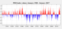
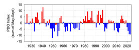
Wow, that is honestly startling to me. I think you are definitely onto something here. I believe you said you've already tried to correlate this with AMO and maybe PDO also? Those are my first (obvious) thoughts but just at a quick glance it appears if there is a correlation, it is with some sort of lag.View attachment 146711View attachment 146712
That +height anom in the pacific coupled with a generally +nao is a menace. I can't put my finger on it unless it has to do with less high latitude blocking on average, the strat pv gradually becoming less apt to break down early, that residual warm SAT tongue that seems to be never ending from Japan to the aleutians now


Attachments
Last edited:
Does the fact the Triangle has now become more of a heat island have anything to do with these declining averages? I mean these measurements were taken at RDU. How about the rural areas just outside the metro? If they are reflective (more or less) equally or maybe even the mountain/foothills in this avg. decline then the dreaded cc acronym might be part of the issue
I actually was just speaking to the NC climate office this morning and they found (unsurprisingly) similar trends statewide. I don't want to share their research without permission, but I can tell you they plotted rolling average annual snowfall for Asheville from 1995-2024 and it went from ~15" to ~10", Greensboro from ~11" to ~7.5", Wilmington from ~2.5" to <1", Charlotte from ~7.75" to ~3.75". However, they also agreed with me that this is more than just climate change. @SD is onto something with the large scale pattern shift. Folks don't want to acknowledge it, but the NAO has historically been a monumental driver of winter weather in the eastern US, especially NC. The absence of that combined with the N PAC ridge is a death knell to winter weather chances.Does the fact the Triangle has now become more of a heat island have anything to do with these declining averages? I mean these measurements were taken at RDU. How about the rural areas just outside the metro? If they are reflective (more or less) equally or maybe even the mountain/foothills in this avg. decline then the dreaded cc acronym might be part of the issue
Again, and the SCO agrees with me here, if we were seeing a lot of cold rain events in the 30s or suddenly we were seeing multiple sleet or freezing rain events instead of snow events with a small, consistent warm nose, then perhaps you look at warming temps. But this is a large scale, seasonal winter patten shift.
It's possible when we look back in 40 more years we flip back - Greenland has already shown a significant increased tendency for blocking the past few winters, maybe we turn it on with the TPV getting further east in winters to come. I don't think anyone truthfully has any idea. If they did, I'm pretty sure everyone's forecasts wouldn't have ended up in the same place as mine this February (dumpster fire).
Great analysis. The recent 40yr period is just awful considering the previous 40 for sure and really kills the overall for 80yrs.I've seen some similar analyses done already, but figured I'd throw mine out here so we can all share in the depressing reality that is NC snowfall trends.
First, I present to you annual snowfall from 1944-1984:
View attachment 146706
'44-'84 mean: 7.44"
'44-'84 median: 5.4"
Next, 1984-2024 annual snowfall:
View attachment 146707
'84-2024 mean: 4.96"
'84-2024 median: 1.7"
Now the whole picture:
View attachment 146708
To me the thing that probably sticks out the most is the '84-2024 median of only 1.7". Once you remove the outlier years of 2000 and a couple of others, it becomes readily apparent that our winters have been really paltry for a long time now. We certainly used to get a lot more sleet/freezing rain events that don't even happen now either, but the end result of no snow has been there for a lot longer than I fully realized.
I've actually reached out to my pals at the NC Climate Office to see if they would consider pulling all hourly data where RDU measured precipitation with the temperature at or below freezing. I believe you would see a dramatic decrease in that as we roll forward in time as well. It's not just snow that has dried up - where are all the sleet and freezing rain / glaze events at? All those nuisance winter weather advisories for a glaze of ice in the morning? It's all gone.
I'm honestly starting to wonder if my kids or at least their kids will be telling stories of how it used to snow at all in Raleigh if we continue down this road. I still don't buy that this is all solely the result of climate change, because it's not like we are suddenly getting a lot of sleet events with a narrow 1-2 C warm layer or partial thicknesses are 1310 m and we are just a degree or two away from frozen precipitation. We aren't even in the ball game anymore. Who knows what the next 40 years of this graph will look like - will we snap back upwards or continue to trend to almost nothing? The 1930s and 40s probably were pretty similar in regards to snowfall to what we're experiencing now over the past 20 years, so who knows.
Quick question--If you are going to throw out the two anomalous heavy snowfall years then shouldn't you also throw out the 2 least snowfall years as well. Isn't that the proper way to deal with outliers in averaging
Good question and just for clarification I didn't throw out any data haha. What I was trying to say is that the median value removes the outliers by focusing on the center of the dataset, so naturally it ignores the extremes on both ends. So it actually is already doing what you ask - ignoring the upper and lower extremes. It's really a sobering fact to consider when you think about the shift in the median from 5.4" to 1.7" at RDU, and just goes to prove that my parents weren't kidding when they said it snowed more when they were young around here.Great analysis. The recent 40yr period is just awful considering the previous 40 for sure and really kills the overall for 80yrs.
Quick question--If you are going to throw out the two anomalous heavy snowfall years then shouldn't you also throw out the 2 least snowfall years as well. Isn't that the proper way to deal with outliers in averaging
I used to think the super nino in the late 90s was what flipped every thing but it seems like it started before that.I actually was just speaking to the NC climate office this morning and they found (unsurprisingly) similar trends statewide. I don't want to share their research without permission, but I can tell you they plotted rolling average annual snowfall for Asheville from 1995-2024 and it went from ~15" to ~10", Greensboro from ~11" to ~7.5", Wilmington from ~2.5" to <1", Charlotte from ~7.75" to ~3.75". However, they also agreed with me that this is more than just climate change. @SD is onto something with the large scale pattern shift. Folks don't want to acknowledge it, but the NAO has historically been a monumental driver of winter weather in the eastern US, especially NC. The absence of that combined with the N PAC ridge is a death knell to winter weather chances.
Again, and the SCO agrees with me here, if we were seeing a lot of cold rain events in the 30s or suddenly we were seeing multiple sleet or freezing rain events instead of snow events with a small, consistent warm nose, then perhaps you look at warming temps. But this is a large scale, seasonal winter patten shift.
It's possible when we look back in 40 more years we flip back - Greenland has already shown a significant increased tendency for blocking the past few winters, maybe we turn it on with the TPV getting further east in winters to come. I don't think anyone truthfully has any idea. If they did, I'm pretty sure everyone's forecasts wouldn't have ended up in the same place as mine this February (dumpster fire).
Do you know if any sites that have SST anomaly maps from the 50s-80s? I'd be curious to know what that -pdo looked like.
I have suggested that while generally warmer temps probably aren't helping us in the snow department, the impact that climate change is having is, in fact, on the larger scale - that it is influencing something that creates a large scale environment that is unfavorable to supporting a -NAO and troughing in the east. But I don't know if that holds water or not.I actually was just speaking to the NC climate office this morning and they found (unsurprisingly) similar trends statewide. I don't want to share their research without permission, but I can tell you they plotted rolling average annual snowfall for Asheville from 1995-2024 and it went from ~15" to ~10", Greensboro from ~11" to ~7.5", Wilmington from ~2.5" to <1", Charlotte from ~7.75" to ~3.75". However, they also agreed with me that this is more than just climate change. @SD is onto something with the large scale pattern shift. Folks don't want to acknowledge it, but the NAO has historically been a monumental driver of winter weather in the eastern US, especially NC. The absence of that combined with the N PAC ridge is a death knell to winter weather chances.
Again, and the SCO agrees with me here, if we were seeing a lot of cold rain events in the 30s or suddenly we were seeing multiple sleet or freezing rain events instead of snow events with a small, consistent warm nose, then perhaps you look at warming temps. But this is a large scale, seasonal winter patten shift.
It's possible when we look back in 40 more years we flip back - Greenland has already shown a significant increased tendency for blocking the past few winters, maybe we turn it on with the TPV getting further east in winters to come. I don't think anyone truthfully has any idea. If they did, I'm pretty sure everyone's forecasts wouldn't have ended up in the same place as mine this February (dumpster fire).
Whatever is going on is blitzing us with -PNAs and seems to make it impossible to end up with temps below normal during the winter season, which obviously makes winter weather more difficult.
I don't think I do. If work ever cuts me a break I may try to dig into this more. The SCO has asked me to help them with some winter weather material they are working on for updated web pages, so I may use some "professional development" time to perform some research haha.I used to think the super nino in the late 90s was what flipped every thing but it seems like it started before that.
Do you know if any sites that have SST anomaly maps from the 50s-80s? I'd be curious to know what that -pdo looked like.
I mean we have legitimate concerns about where our snow is going I think it checks out lolI don't think I do. If work ever cuts me a break I may try to dig into this more. The SCO has asked me to help them with some winter weather material they are working on for updated web pages, so I may use some "professional development" time to perform some research haha.