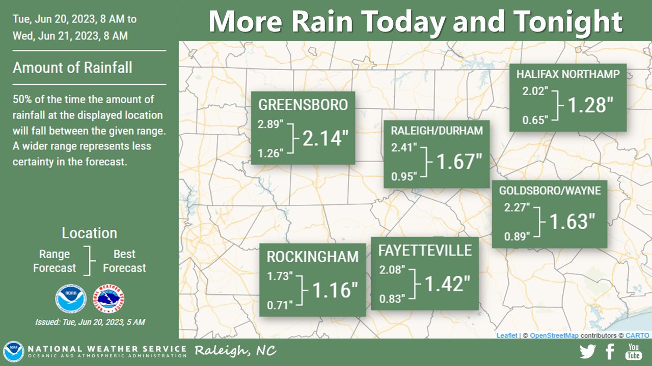
Interested to see how this plays out. It's the time of year here in JoCo where it rains all around us and not IMBY. Missed every drop yesterday and grass is officially brown and crunchy.This is new from NWS
-
Hello, please take a minute to check out our awesome content, contributed by the wonderful members of our community. We hope you'll add your own thoughts and opinions by making a free account!
You are using an out of date browser. It may not display this or other websites correctly.
You should upgrade or use an alternative browser.
You should upgrade or use an alternative browser.
Pattern June 2023 Thread
- Thread starter SD
- Start date
The HRRR did well yesterday showing basically a swing and miss this way and the band setting up east of Charlotte through GSO and that's exactly what happened. Now it has some banding setting up through this area late this evening as the flow turns southeast. Totals could add up but it could very well be another swing and miss. Like I said yesterday the coverage is nothing like a tropical system and there will be big winners with the 6-7 inch totals, mainly along the escarpment and some big losers by FridayThe 6z GFS continues the trend. This event may already be about over in the GSP county warning area outside of the mountains and upslope areas north of I-85. It shows less than 1.25 of additional rain now for many of us through hour 108.
Over an inch already today 1.75 for the event so far
Cary_Snow95
Member
Approaching 2” on the day in Cary. Got 0.6” yesterday. So already 2.6” in 18 hours
Very Land Falling Tropical feel here in the Western Carolinas:
DP: 72.1
Temp: 74.1
Rain for event: .75
DP: 72.1
Temp: 74.1
Rain for event: .75
Shaggy
Member
We are getting blanked so far with just little spotty drizzle snd sprinklesOver an inch already today 1.75 for the event so far
Round 2 is a miss here too.
 ??
??JHS
Member
The GFS is still slowly trending drier.
Twister
Member
So you're just a GFS Hugger??The GFS is still slowly trending drier.
 you will probably be changing your tune after tomorrow
 Sent from my SM-S911U using Tapatalk
JHS
Member
It is not just the GFS. One of the other models shows me getting an amazing .05 out if this from here on out and it is probably right.So you're just a GFS Hugger??you will probably be changing your tune after tomorrow
Sent from my SM-S911U using Tapatalk
Brick Tamland
Member
Great photo of a shelf cloud at the OBX.

Cary_Snow95
Member
3.20” for the event so far in Cary
I’m at a solid 1.9” since things started at noon yesterday.3.20” for the event so far in Cary
Jackpot Jimmy ? 
There’s no way that can miss Jonesville!Jackpot Jimmy ? View attachment 135530

0.4 so far even I thought I'd have had more by now. I go back to work tomorrow and have to work outside down around Simpsonville and Greenville so I guarantee it'll be throwing down there.
? 
Still only .85” here. Several sprinkles, but the game of being avoided continues unless it is widespread.
You’re going to have places in moderate drought while areas ten miles away are in a surplus.
You’re going to have places in moderate drought while areas ten miles away are in a surplus.
JHS
Member
It fell apart before getting here and the new stuff to the south will miss too. I knew how this would go when we missed yesterday morning. I'm going to be lucky to get another drop here out of this.There’s no way that can miss Jonesville!View attachment 135532