Follow along with the video below to see how to install our site as a web app on your home screen.
Note: This feature may not be available in some browsers.
Hello, please take a minute to check out our awesome content, contributed by the wonderful members of our community. We hope you'll add your own thoughts and opinions by making a free account!
This line of storms really squeezed a lot of moisture out of the atmosphere in southeastern TX, the airmass is moistening out ahead of it over Louisiana and extreme SE TX indicated by the increasing dew points...
The environment doesn't look to shabby for a few severe thunderstorms and an isolated supercell or two tomorrow in southeast GA and north FL, biggest question wrt upgrade to a slight risk will likely be instability and/or any upscale convective growth...
Here's a 4 km NAM sounding depicting a legitimate risk for an isolated tornado or two
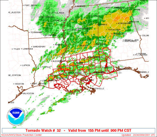
Classic looking backwards C in the squall line heading towards Houston, need to watch for a brief spin-up tornado here...
A tornado warning is actually in effect for the Houston Metro right now
This site uses cookies to help personalise content, tailor your experience and to keep you logged in if you register.
By continuing to use this site, you are consenting to our use of cookies.